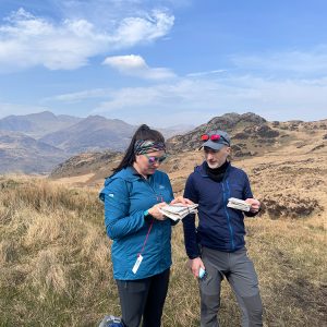
This is a great place to start if you want to learn how to use a map and compass to navigate safely outdoors. This is a one-day course that will take place on lower-level routes on recognised paths and bridleways.
Course Objectives
- Understand the basics of maps and scales
- Learn how to take a grid reference
- Understand the symbols on a map
- How to orientate the map and identify features around you
- How to measure and estimate distance
- Plan and follow simple routes using basic navigation strategies
- Understand the basics of map contours
- Understand the basic use and purpose of a compass
- Understand Rights of Way
- What to do if you get lost
- Managing emergencies in the outdoors
Equipment
Maps and compasses are provided.
- Waterproofs (Upper and lower body)
- Warm layers (including spare items for any emergencies in your kit bag)
- Hats/gloves (appropriate to time of year)
- Any food/water/hot flask (there are no refreshments en route during the day)
- Personal medications and suncream
- Supportive and appropriate footwear
- Headtorch (for emergency use only)
- Gaiters are optional, but I do find they keep my boots drier for longer and protect my legs and trousers from the heather/gorse/bracken*
- A stopwatch or watch with a stopwatch function*
- Notebook, if you like to make notes*
- Sit mat*
- Walking poles if needed*
(*optional)
More Information
If you have any questions or want more information, get in touch via the contact page, or email.
Please note – full course information, including the meeting point, will be sent out approximately 4 weeks before the course.
Consent Forms – Medical Consent forms must be completed before the course starts. You can find the forms here.
Please read my Terms and Conditions.